


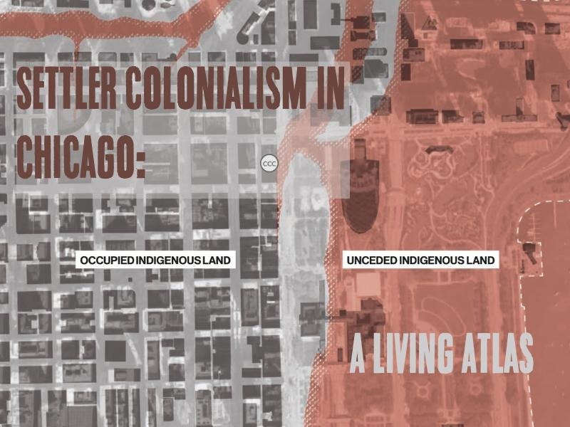
In 2019, a research collective called the Settler Colonial City Project was invited to participate in the Chicago Architecture Biennial. Among the work that our collective contributed to the biennial was an atlas of Chicago’s colonial settlement. Mapping Chicagou/Chicago: A Living Atlas brings together three geographies that have been at once produced by and held apart by settler colonialism: the geography of Native American displacement in the United States; the geography of colonial land-filling and water-seizing in and around Lake Michigan; and the geography of Chicago’s urban development. Bringing these geographies together allowed us to document the way in which the city of Chicago has been shaped by settler colonialism, as well as the way in which Indigeneity has persisted and thrived even in the context of colonialism’s displacements, dispossessions, and violence.
Settler colonialism not only yielded the city of Chicago but continues to structure relationships between land, people, and “the environment.”
We entitled our atlas Mapping Chicagou/Chicago in order to reference the way in which settler colonialism not only yielded the city of Chicago but continues to structure relationships between land, people, and the multifarious elements of what in colonial ontology is named as “the environment,” “nature,” or “the natural world.” We also wanted to reflect on the name “Chicago,” which references a French rendering of the Miami-Illinois word for a type of wild onion, the shikaakwa, known in English as ramp. Shikaakwa was later turned into checagou or chicagua, also in reference to a type of garlic that grew in the forests and plains of the region. With the colonization of the place known as Chicagou, along with other related names, the ramps and garlic that were harvested and sustained by Indigenous people in these forests and plains were replaced by wheat, a crop indigenous to the Fertile Crescent brought to North America by British colonialism.
Even as the colonial replacement of shikaakwa by wheat may have been almost total, settler colonialism has yielded practices of displacement, dispossession, and violence that continue to structure the development of Chicago. Mapping Chicagou/Chicago, then, contests the colonial framing of settler colonialism in the United States as merely a historical phenomenon, long since passed in the history of the United States. In fact, our documentation of Chicago as a city located on both occupied and unceded Indigenous land reveals the city’s geography as a product of conflict, violence, and struggle that continue into the present. We therefore pose the maps in Mapping Chicagou/Chicago as a living atlas: counter-geographies of settlement and unsettlement that contests the colonial geography framing colonialism in Chicago as a historical artifact.
Mapping Chicagou/Chicago
The following seven maps from Mapping Chicagou/Chicago are constituent parts of this counter-geography. These maps were drawn by Emily Kutil and Tyler Schaafsma, two of our collaborators in our project for the Chicago Architecture Biennial.

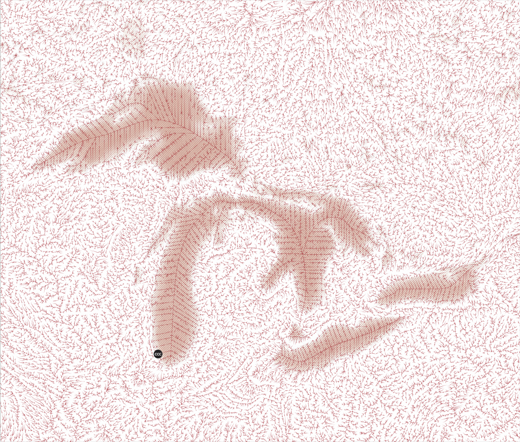
Colonial cartography typically renders “land” and “water” as categorically different entities. This rendering emerges from the differential histories of land and water in imperial, colonial, and capitalist contexts: while land became private property that could be bought and sold by individuals, water became the collective property of nation-states or empires. By contrast, Indigenous world views recognize land and water as categorically related to both each other and to the human and non-human beings who support and are supported by land and water.
Hydroshed maps, then, might approach Indigenous worldviews closer than other forms of colonial cartography. At the same time, however, hydroshed maps also register the inability of colonial cartography, and colonial worldviews more generally, to fully grasp the interrelatedness of land and water. This inability is revealed in the rigid lines that stand in for the hydroshed lines that the system is unable to trace because, in contrast to hydroshed lines on the land, these lie deeply submerged under the water of the Great Lakes. This hydroshed map of the Great Lakes thus acknowledges both conditions: the continuity of an Indigenous landscape and the incapacity of colonial tools of cartography to adequately render this continuity. The hydroshed map, then, is an acknowledgement of the settler inability to fully grasp Indigenous understandings of the world; at the same time, the map points to the decolonial imperative to acknowledge and respect those understandings.

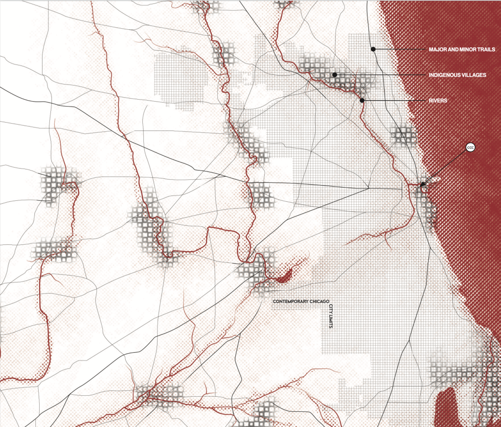
Source of map data: Albert Scharf, “Map of 1804 Indian Trails and Village of Chicago and of Cook, Dupage, and Wiill Counties, Illinois,” 1900.
Land and water were not only conceptually and spiritually connected in Indigenous worldviews, but also practically enmeshed. Indigenous settlements in Chicagou and its environs followed waterways that were used to guide travel through and across the land—waterways that also guided the movement of the non-human beings that supported and were supported by land and water. These Indigenous settlements formed a network not only across the land but within the land–a network that bound the land together with human beings, animals, plants, water, and other animate and non-animate entities into a sustaining and sustained system.
This network had its own scale and form, different from colonial settlement patterns. The outline of contemporary Chicago, seen on the map in grey, provides a sense of the scale on which land was inhabited by Indigenous populations before treaties and before the incorporation of the city.

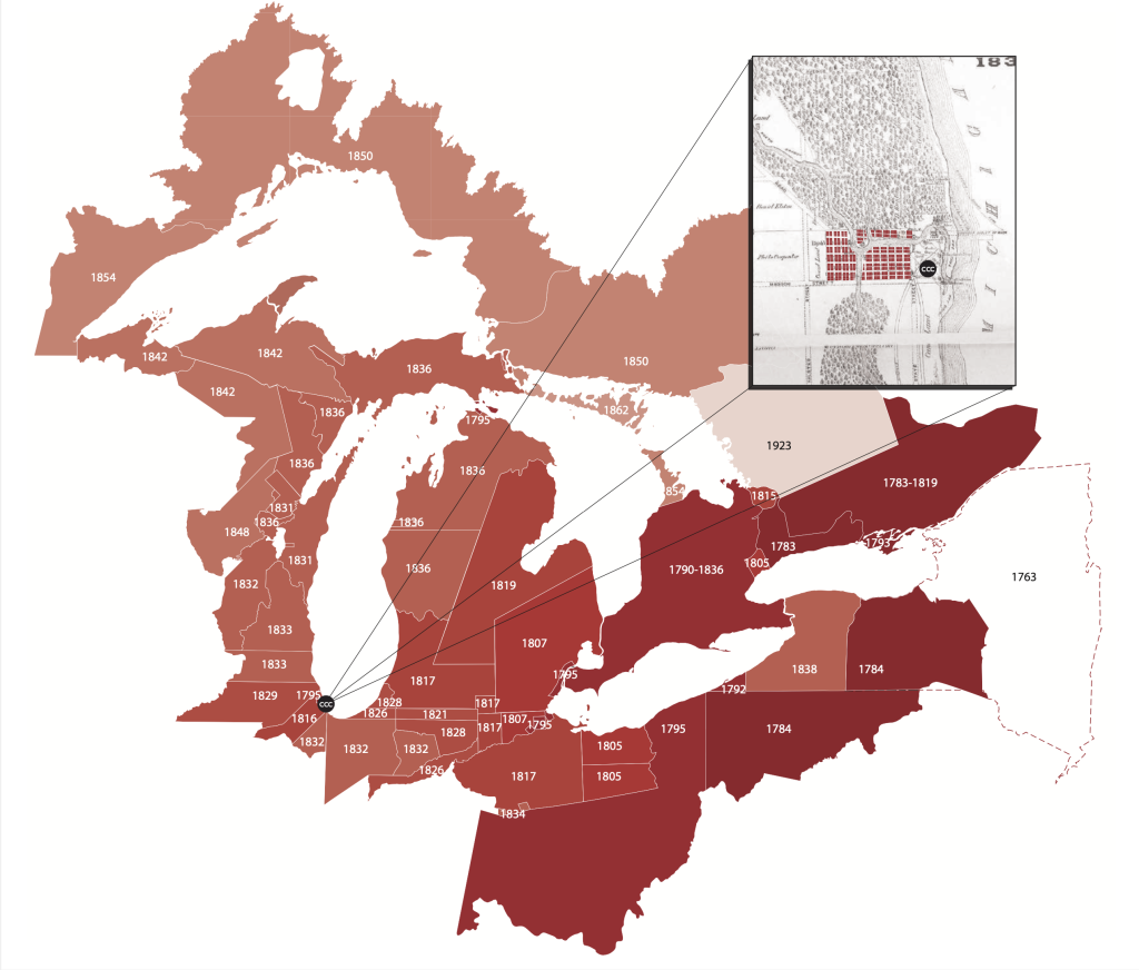
Source of map data: “Canada First Nations and Treaties,” “Library of Congress Indian Land Cession Maps,” “Map of Chicago in 1830,” 1886; “Thompson’s Plat of 1830.”
In the United States and elsewhere across the globe, settler colonialism was a project to seize land from the Indigenous people who inhabited and sustained it and transfer that seized land to the colonial state. In the United States, this seizure was accomplished by a conjoined program of coerced treaties between the U.S. government and Indigenous people and frontier violence, both state-sponsored and state-encouraged. Colonial land seizure not only displaced Indigenous people and the non-human beings they lived with from the land and water; it also transformed land and water into categorically different entities.
The territory where contemporary Chicago stands was initially surveyed with reference to the Third Principal Meridian that was set in 1805. In 1833, twenty-eight years after the land had been occupied by the surveying geometry, the U.S. government imposed the Treaty of Chicago on the Ojibwe, Ottawa, and Potawatomi Nations. Four years later, in 1837, the city of Chicago was incorporated. The platting of the land preceded land seizure but both actions should be understood together, as part of the set of settler colonial technologies that codified, occupied, and confiscated land from its Indigenous occupants.
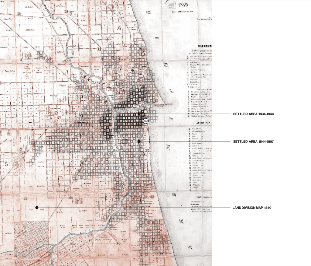
Source of map data: “1849 Rees & Rucker Map of Chicago and Vicinity“; Homer Hoyt, One Hundred Years of Land Values in Chicago (Chicago: University of Chicago Press, 1933), figure 18.
Before the 1871 Fire, Chicago developed on land seized from Ojibwe, Ottawa, and Potawatomi Nations. The dispersed low-density settlements and sustaining land practices of these and other inhabitants of the land were thereby replaced by a fast-growing and increasingly- capitalized modern city developed on the basis of a grid laid out over the land and a new infrastructure. This infrastructure—first a series of water canals and then an expanding rail network—transformed Chicagou into Chicago, a city built to connect the landscapes of colonial extraction on the United States Plains and West to shipping and trading sites on the Atlantic Coast and beyond.
Two narratives are made visible in this map: one, the gridding and platting of the land, which suggests the land’s settlement, and the other, the actual presence of a settler population that is assumed to be generically “human.” Neither of these narratives is accurate and their inaccuracy opens onto a more complicated history. Much of the gridded and platted land was not settled and the settlement of the grid, mapped by Homer Hoyt in his 1933 book, One Hundred Years of Land Values in Chicago, only included white settlers. Thus, this map of the “settlement” of Chicago in the 19th c. is more precisely a map of the conjoined unsettlement of Indigenous peoples and settlement of settlers in Chicago over this time. “Settlement” was reserved for settlers: this is an axiom of settler colonial geography.
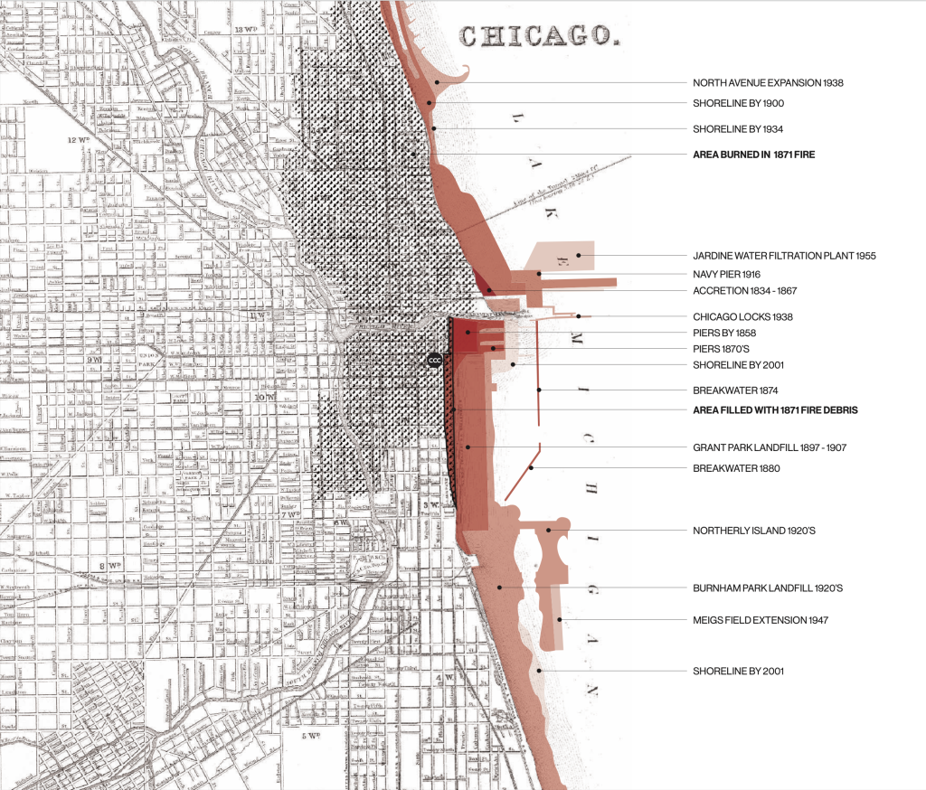
Source of map data: “Richard’s Illustrated and Statistical Map of the Great Conflagration in Chicago,” 1871; “Chicago’s Lakefront Landfill,” 2004.
Today’s Millenium Park, Grant Park, and Burnham Park is territory that was at once new land and unceded land.
The 1871 Fire both destroyed a large part of a growing city and also created conditions for the city’s even more rapid post-fire expansion—rubble from the fire became land fill used to grow the city east of Michigan Avenue, which had previously run along the Lake Michigan shoreline. The thin sliver of land marked as filled from the fire debris points to the success of the fire narrative in propelling the landfill operation. This new urban territory, encompassing today’s Millenium Park, Grant Park, and Burnham Park, took form on what was water when the Treaties of Chicago were signed; this territory, then, was at once new land and unceded land. In the early 1900s, in the course of land filling, the Pokagon Band of Potawatomi Indians, who remained in Michigan and Indiana after the 19th century land seizures, asserted a claim to the unceded land this filling created and in 1914 they sued the City of Chicago and other landowners as part of this assertion. The case went to the U.S. Supreme Court, which decided that the Potawatomi “abandoned” this land, despite the fact that this land did not exist when the Potawatomi signed the 1833 Treaty of Chicago.
Forcing the Supreme Court, and the settler colonial state this court represented, into an absurd argument, the Potawatomi exposed the gap between the state’s avowals of equality and democracy and its ongoing practice of Native American dispossession.
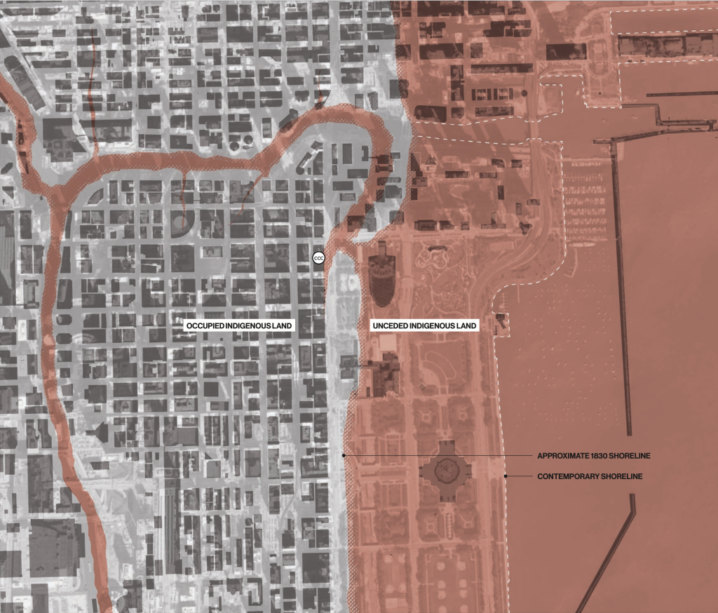
Source of map data: “Map of Chicago, Incorporated as a Town August 5, 1833,” 1933; “Lake View Historical Chronicles.“
Contemporary Chicago is built on occupied land. This land consists of both territory ceded through treaties that the U.S. government coerced Native Americans to sign and unceded territory created by landfill after those coerced treaties were signed. The frontier between ceded and unceded land—corresponding to much of Michigan Avenue south of the Chicago River—is denied and invisibilized by the beneficiaries of settler colonialism, but it is also asserted and visualized by the Indigenous people who colonialism displaced, along with their accomplices.
Source of map data: “Chekagou’s First Culture: The Native American City, Then and Now;” “Without Native Americans, Would We Have Chicago As We Know It?“
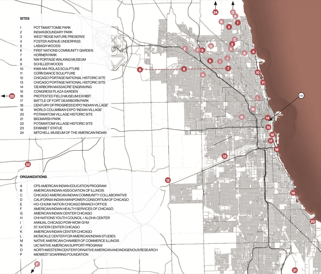
While 19th century settler colonialism almost completely displaced Indigenous people from the space that became Chicago, Indigenous people returned in large numbers to Chicago and its environs in the wake of the U.S. government’s 1956 Indian Relocation Act. This Act sought to destroy the remaining spaces of Indigenous identity and self-determination in the United States by discontinuing federal funding for many reservation-based services, decreasing subsidies to reservation-based Native Americans, and ending federal recognition of many tribes. In the wake of the Relocation Act, many Indigenous people migrated to cities, with Chicago becoming a destination for many Indigenous families. The founding of Chicago’s American Indian Center in 1953–the first urban community center for Native Americans in the United States–reflects the importance of the city for Native Americans in the post-Relocation Act era.
With some 65,000 Native Americans from around 175 different tribes in its greater metropolitan area, Chicago today has the third-largest population of urban Native Americans among U.S. cities. The presence of Native Americans in Chicago is reflected across the city in a wide range of sites, ranging from murals and memorials, through community centers and social service providers, to historic sites. This network of Indigenous sites created by Indigenous people exposes the vivid Indigenous presence in contemporary Chicago.
The dispersed location of these sites across the city also testifies to the network of Indigenous settlements that predated and configured Chicago. This echo across centuries hints at the presence of Chicagou within Chicago, a living presence that, together with the scars caused by settler colonialism, is a vital part of the city’s history, contemporaneity, and futures.